1. Introduction
The estuaries that open into the Bay of Bengal, from the Godavari and Krishna deltas through the Mahanadi and the Sundarbans to the Ayeyarwady, carry some of the most extensive mangrove forests in Asia and some of its densest coastal populations. Aquaculture ponds, paddy bunds, salt pans and reduced freshwater flow have removed or degraded large parts of these forests. Restoration has followed, driven by forest departments, donors and, after each major cyclone, by renewed interest in coastal protection.
Results have often been poor. Reviews of planting programmes in the Philippines and Sri Lanka found low survival across most sites, largely because seedlings were put in the wrong places (Primavera and Esteban, 2008; Kodikara et al., 2017). Even where trees survive, success is usually reported as hectares planted or seedlings alive. Fishing households tend to judge a mangrove by a different measure: whether juvenile shrimp, crab and fish return to its creeks.
This article proposes a framework for planning a community-led restoration in a Bay of Bengal estuary and for monitoring the recovery of its nursery function. It describes a procedure and the reasoning for each part. It does not report a project, and no site, community or data set stands behind it. The framework has not been validated here.
2. Background
Three bodies of published work inform the design. They concern why planting fails, what a nursery is and how it can be measured, and what makes shared management of a resource last.
2.1. Hydrology before planting
Lewis (2005) set out the approach now called ecological mangrove restoration. Mangroves occupy a specific band of the intertidal zone, roughly between mean sea level and high water of spring tides, and each species has its own tolerance of flooding depth, duration and salinity. If a site has lost its mangroves, the first task is to find out why. Where tidal exchange has been cut by a bund or a road, reopening it often allows propagules carried on the tide to establish without any planting. Planting is a supplement for sites that propagules cannot reach. Ellison (2000) reached a similar position, that enough is known about mangrove ecology to restore forests and that failures come mostly from ignoring it.
Tree cover is a first step and not the goal. A review of restored stands found that faunal recolonisation, nutrient cycling and other functions can approach those of natural forest, but over different periods and not in every case (Bosire et al., 2008). International restoration standards accordingly ask that a project define a reference ecosystem and measure recovery against several attributes, among them species composition, structure and function (Gann et al., 2019).
2.2. The nursery function
Juveniles of many fish and crustaceans concentrate among mangrove roots and in the creeks that drain them. The accepted explanations are structural shelter, reduced predation in shallow turbid water and abundant food (Laegdsgaard and Johnson, 2001; Nagelkerken et al., 2008). High density alone does not make a nursery. Beck et al. (2001) defined a nursery as a habitat that contributes more recruits to the adult population per unit area than other habitats in which juveniles occur, through some combination of density, growth, survival and successful movement to adult grounds. Dahlgren et al. (2006) added that the overall contribution of a habitat also matters, and Sheaves et al. (2015) argued that nursery value belongs to connected mosaics of mangrove, mudflat and channel more than to a single habitat. Most evidence linking mangrove area to fishery catch is correlational (Manson et al., 2005), which is a further reason to measure the response directly.
2.3. Institutions for shared management
A restored stand is a common-pool resource: villagers can cut poles, graze cattle or net juveniles in it, and one household's restraint benefits all. Ostrom (1990) identified features of institutions that have managed such resources for long periods, including clear boundaries, rules made by the users, monitoring by people answerable to them, graduated sanctions and recognition by the state. A review of community-based mangrove management found that tenure security, a visible flow of benefits and sustained outside support separated lasting efforts from short-lived ones (Datta et al., 2012).
3. The Proposed Framework
The framework has six phases arranged as a cycle, shown in Figure 1, with a village mangrove committee at the centre. Table 1 lists each phase with its lead and the record it should produce. The phases are described below in order.
| Phase | Main tasks | Led by | Record kept |
|---|---|---|---|
| 1. Diagnose | Map elevation, tides, salinity, past cover and causes of loss | Committee with technical partner | Site map and diagnosis note |
| 2. Agree | Settle boundaries, access rules, roles and benefit sharing | Village assembly | Signed agreement |
| 3. Restore flow | Breach bunds, clear or re-dig creeks | Committee work groups | Works log with photographs |
| 4. Assist regeneration | Protect recruits; plant only where recruitment fails | Committee work groups | Planting and survival register |
| 5. Monitor | Survey vegetation plots and juvenile fish in fixed creeks | Trained village monitors | Data sheets and season summary |
| 6. Review | Compare results with targets and change the plan | Assembly and partners | Annual review minutes |
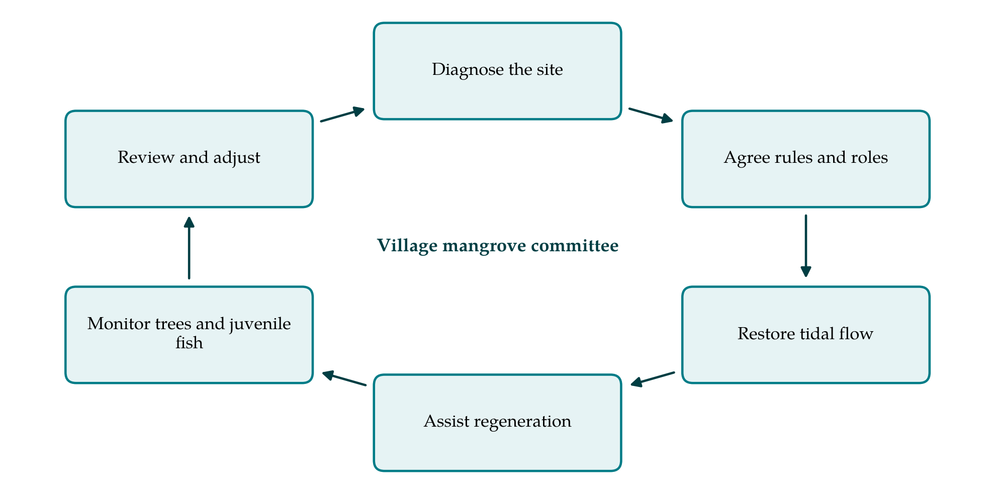
3.1. Phase 1: Diagnose the site
The committee and a technical partner walk the site at spring and neap tides and record where water reaches and how long it stays. Ground level is surveyed against a tide staff, since a difference of a few tens of centimetres decides which species, if any, can grow. Salinity is measured in creeks and soil water in the dry season and after the monsoon. Old maps, satellite images and the memory of older residents establish where mangroves stood and what removed them. A nearby intact stand at similar elevation is chosen as the reference, and its species zonation noted: typically Avicennia marina and Sonneratia apetala on the accreting seaward edge, Rhizophora along creek banks, and Excoecaria agallocha and Ceriops on higher ground.
3.2. Phase 2: Agree rules and roles
Before any earth is moved, the village assembly settles who may use the site and how. The agreement fixes the boundary on the ground, names the committee and its term, sets rules on cutting, grazing and fine-mesh netting inside the restored creeks, and states how wages for restoration work and any later harvest will be shared. Groups with a direct stake, among them women who collect crab and shrimp seed and households that hold or lease former ponds, need seats on the committee and not only a hearing. The agreement should be registered with the forest department or local government, so that the community's rights are recognised by the authority that holds legal title.
3.3. Phase 3: Restore tidal flow
Works follow the diagnosis. Abandoned pond bunds are breached at the points where former creeks crossed them, silted channels are re-dug by hand to their old course, and culverts are opened under paths. The aim is a pattern of flooding and drainage close to that of the reference stand. Where the ground has subsided or been excavated, spoil from the breaches can raise it to the level at which the reference species grow. Work is timed for the dry season, when access is easiest and labour is available.
3.4. Phase 4: Assist natural regeneration
The site is then watched through one full fruiting season. If propagules arrive and establish, the committee's task is protection: fencing against cattle and goats and enforcing the agreed rules. Planting is reserved for areas where no recruits appear, and uses species matched to the measured elevation and salinity, raised from local seed. Single-species blocks of Rhizophora on bare lower mudflat, the pattern that failed elsewhere (Primavera and Esteban, 2008), are excluded by the diagnosis.
3.5. Phase 5: Monitor vegetation and juvenile fish
Vegetation is recorded in permanent plots laid along transects from creek edge to landward margin, in the restored site and the reference stand. Monitors count seedlings and saplings by species and measure stem diameter and height of trees, following published protocols for mangrove plots (Kauffman and Donato, 2012). Fixed photograph points add a record that anyone in the village can read.
Fish monitoring is designed so that a change at the restored site can be told apart from a good or bad year in the estuary as a whole. The logic is that of before-after, control-impact designs (Stewart-Oaten et al., 1986), extended to several control locations as Underwood (1994) recommended. Three kinds of creek are sampled: restored creeks, reference creeks in intact mangrove and unrestored creeks in degraded ground. Sampling starts before the bunds are breached and continues on the same schedule afterwards. A divergence of the restored creeks from the unrestored ones, and towards the reference, is the signal sought.
Gears must suit small tidal creeks and village operators. A block net set across a creek mouth at high water, with the catch collected as the creek drains, samples a known area. Fyke nets and local bamboo traps are alternatives where a creek cannot be closed. Sampling is repeated on set lunar phases in the pre-monsoon, monsoon and post-monsoon seasons. Monitors identify the catch to an agreed list that includes commercially important juveniles such as penaeid shrimp, mud crab (Scylla), mullets and barramundi (Lates calcarifer), count individuals, measure the length of a subsample and release live animals. Density and size structure of juveniles are the main indicators. They address the density component of the definition by Beck et al. (2001); growth, survival and movement to adult stocks lie beyond a village programme.
Participatory monitoring ranges from schemes run by outside scientists with local help to schemes designed and interpreted by local people, and the authors of that typology argue that the more locally driven kinds tend to feed more directly into management decisions (Danielsen et al., 2009). The framework places itself towards the local end. The technical partner trains monitors, checks a share of identifications against photographs or retained specimens, and helps with analysis.
3.6. Phase 6: Review and adjust
Once a year the assembly meets with its partners to compare results with the targets set in the diagnosis: flooding regime, recruitment, canopy cover, and juvenile density relative to reference creeks. Shortfalls lead back to the appropriate phase. Persistent waterlogging calls for further channel work, repeated grazing damage for a change in rules or their enforcement.
4. Fitting the Framework to Bay of Bengal Conditions
Several features of the region shape how the framework would be used. Tidal range is large in the northern bay and small along parts of the Coromandel coast, so the width of the zone suitable for mangroves, and the gear that works in the creeks, differ from one estuary to another. Monsoon river flow drives a strong seasonal swing in salinity, which affects both seedling establishment and the juvenile fish present; comparisons must therefore be made season by season. Tropical cyclones can flatten young stands and re-close creeks with sediment, and the review phase should include an inspection after every severe storm. Land status is frequently contested between revenue, forest and fisheries authorities, and the agreement of the second phase has little force until that question is settled.
5. Limitations and What Remains to Be Shown
The framework is a proposal built from published principles, and its parts have not been tested together. Whether village monitors can produce fish data consistent enough to detect a change is the first open question, and it depends on training, on turnover among monitors and on how variable creek catches prove to be. A second is duration. Restored stands take years to develop structure, and faunal recovery may lag further (Bosire et al., 2008), so a programme that ends with its funding after two or three seasons will record only the beginning.
A third limitation is inferential. A rise in juvenile density in restored creeks shows that young animals use the habitat. It does not show that the estuary produces more adults, since fish may simply have moved from neighbouring creeks. Tagging, otolith chemistry or stable isotope work would be needed to trace contribution to adult stocks, and these require a research partner. Finally, the framework assumes a community able and willing to organise. Where households are divided over the land, or where outside interests control the former ponds, the second phase may fail, and no technical design can substitute for it.
6. Conclusion
The framework proposed here treats mangrove restoration as two linked tasks: bringing back a tidal forest by repairing hydrology and protecting natural recruitment, and finding out, with methods a village can run, whether juvenile fish and crustaceans return to it. It gives the community the lead, asks for an agreement before works begin, and builds in controls so that the fish data can bear interpretation. Its elements come from an established literature. Their combination remains to be tried, and a pilot in a single estuary, reported with its difficulties, would be the appropriate next step.
Conflict of interest
To be declared by the author(s) before publication.
Funding
To be declared by the author(s) before publication.