1. Introduction
The water between the beach and the inner shelf moves under the combined push of tides, wind, waves, river outflow and the larger shelf circulation, and the result changes over hundreds of metres and within hours. Managers need to know that motion for practical reasons: to place an outfall, to judge where a spill will come ashore, to brief a search for a missing swimmer. The instruments that oceanography normally brings to the task leave the nearshore poorly covered. High-frequency radar maps surface currents over wide areas of the coastal ocean, but its cells are typically a kilometre or more across and the band nearest the coast is often blanked (Paduan and Washburn, 2013). Moored profilers give excellent time series at one place and say nothing about the next headland.
Drifters are the natural complement. A drifter is a float designed to move with the water around it, and its successive positions trace the path a parcel of water would have taken. The method is old, and the accounts of its modern form make clear that the hard problem has never been tracking but water following (Lumpkin et al., 2017). What has changed is the cost of the tracking. A receiver for global navigation satellites that once defined the budget of an experiment is now a component costing little, and several groups have shown that drifters built around such receivers return useful data in lakes, estuaries and surf zones (Johnson et al., 2003; Schmidt et al., 2003).
Cheap instruments invite a different way of working. If a drifter can be built from plumbing parts and lost without great regret, many can be released at once, and the people who release and recover them need not be professional oceanographers. This article sets out a procedure for nearshore current mapping in which trained community volunteers carry out the fieldwork. The procedure is a proposal. It is drawn from published designs and analysis methods and has not been applied or tested by the author in the field.
2. Background
Three bodies of work inform the design: the engineering of water-following drifters, the experience of low-cost nearshore instruments, and the literature on data quality in volunteer science.
2.1. Water following and slip
A float at the surface is pushed by the wind on its exposed part and by waves, as well as by the current. The difference between its motion and that of the water is called slip. Open-ocean practice controls slip with a large drogue: the Surface Velocity Program drifter hangs a holey-sock drogue centred at fifteen metres beneath a small surface float, and its slip was calibrated against current meters by Niiler et al. (1995) as a function of wind speed and of the ratio of drogue drag area to that of the other parts. The instrument and its data are described by Lumpkin and Pazos (2007). For coastal work the reference design is the drifter developed for the Coastal Ocean Dynamics Experiment, in which four fabric vanes span the upper metre of the water column and only a small antenna housing breaks the surface (Davis, 1985). Trials with drogued and undrogued units in the Mediterranean confirmed that wind-induced slip is small for the former and large for the latter (Poulain et al., 2009).
2.2. Low-cost nearshore designs
Johnson et al. (2003) described a compact drifter for the nearshore zone, lakes and estuaries built around a logging receiver in a sealed tube with a parachute-style drogue. Schmidt et al. (2003) built a surf zone drifter whose submerged body and damping plate kept it from surfing shoreward on breaking waves. MacMahan et al. (2009) examined whether inexpensive handheld receivers were accurate enough to measure surf zone currents and concluded that, with post-processing, they were. Mobile telephone networks have been used to return positions from coastal drifters in real time (Ohlmann et al., 2005), and a biodegradable drifter was later designed so that hundreds could be released without recovery (Novelli et al., 2017). Student-built drifters have also contributed to regional studies of coastal currents (Manning et al., 2009).
2.3. Volunteers and data quality
Citizen science has a substantial literature of its own. Bonney et al. (2009) described a model in which scientists frame the question and the protocol and volunteers collect the data, and that is the model adopted here. Kosmala et al. (2016) reviewed the evidence on the quality of volunteer data and found that it can match professional data where the protocol is simple, training is given, the instruments are standardised and the records are checked. Each of those conditions is built into the procedure below.
3. The Proposed Procedure
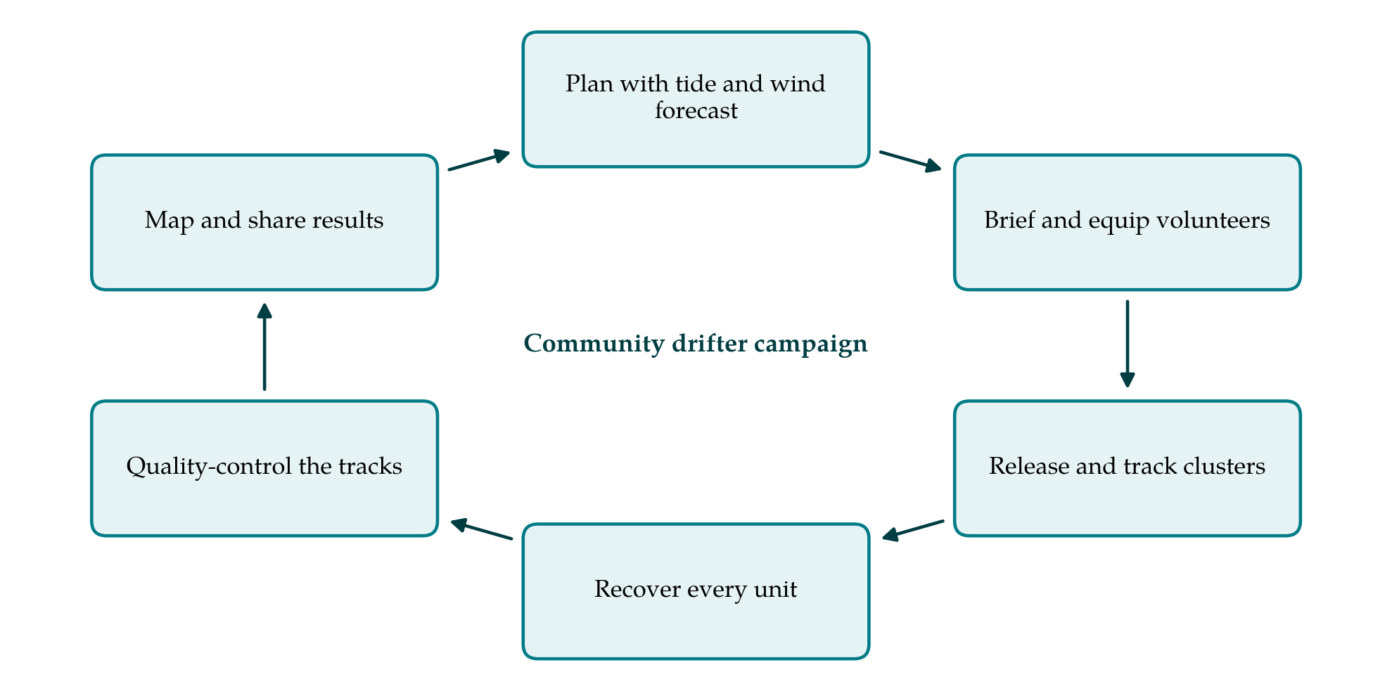
The procedure has six stages that repeat with each campaign, as shown in Figure 1. The paragraphs that follow take them in order, beginning with the instrument, which must be settled before the first campaign and reviewed after each.
3.1. Choosing and building the drifter
No single geometry suits every site, and the first decision is to match the drifter to the depth and wave conditions. Table 1 compares the options. For open bays and inner-shelf water deeper than about two metres, a vaned drifter after Davis (1985) is proposed: a central tube carrying four arms from which fabric panels hang, with small floats at the arm ends. For surf zones and very shallow estuaries a short ballasted tube with a damping plate is more suitable. Both can be made from polymer pipe, sailcloth and fishing floats. The tracking unit should log position at intervals no longer than one minute, hold charge for a full day, and sit in a waterproof housing at the top of the tube. Every unit carries a number, a contact telephone and a line of text asking finders to report it.
| Type | Suited to | Strength | Limitation |
|---|---|---|---|
| Four-vane drifter (Davis, 1985) | Bays and inner shelf deeper than about 2 m | Low wind slip; follows the top metre | Bulky; grounds in shallows |
| Ballasted tube with damping plate (Schmidt et al., 2003) | Surf zone | Resists surfing on breaking waves | Samples a shallower layer |
| Tube with parachute drogue (Johnson et al., 2003) | Lakes, estuaries, sheltered coast | Compact and quick to build | Drogue can foul on weed |
| Undrogued float | Tracing floating debris or oil | Simplest; shows windage directly | Does not represent the current |
| Biodegradable drifter (Novelli et al., 2017) | Large releases without recovery | No retrieval needed | Higher unit cost; satellite fees |
3.2. Checking position accuracy
Before any release, all units are switched on and left together at a fixed point with a clear sky for at least an hour. The scatter of the logged positions about their mean gives the noise of each receiver, and a unit that wanders much more than the others is withdrawn. The same test fixes the shortest interval over which a velocity can sensibly be computed: the displacement over that interval must be several times the position noise. This simple stationary test follows the approach used to assess handheld receivers for surf zone work (MacMahan et al., 2009).
3.3. Planning releases
Campaigns are planned around the tide. A complete picture needs releases on the flood and on the ebb, at springs and at neaps, and in at least two contrasting wind conditions. Within a campaign, drifters go into the water in clusters of three or more, a few tens of metres apart, at release points agreed on a chart beforehand. Clusters serve two purposes. Agreement among neighbours guards against a single faulty track, and the rate at which a cluster spreads is itself a measurement of dispersion. The release points should include the features of local concern, such as a river mouth or an outfall, and should be repeated from campaign to campaign so that results can be compared.
3.4. Working with volunteers
Volunteers are organised in boat teams of at least two, each with a team leader who has attended a half-day briefing. The briefing covers the purpose of the work, how to switch on and seal a unit, how to lower it without tangling the vanes, and how to complete the log sheet, which records unit number, time, position of release and recovery, wind estimated on the Beaufort scale, and anything unusual. Safety rules are those of the host organisation and take precedence over the science: lifejackets are worn, no boat goes out alone, and a campaign is cancelled if the forecast exceeds agreed limits. A shore coordinator holds the list of units in the water and confirms that each has been recovered.
3.5. Quality control and analysis
Tracks are trimmed to the interval between release and recovery using the log sheets. Position fixes that imply impossible speeds are removed and short gaps are interpolated, in the manner long used for the global drifter data (Hansen and Poulain, 1996). Velocities are computed by centred differences over the interval established in the stationary test. Where wind was measured, a slip correction proportional to wind speed may be applied, with a coefficient taken from the literature for the geometry in use and stated in the record. Tracks are then plotted by tidal phase and the velocities averaged in spatial bins to give maps of mean flow and its variability. For clusters, the growth of mean separation between pairs with time gives a relative dispersion estimate; the statistics and their pitfalls are set out by LaCasce (2008), and the technique was applied to large releases in the Gulf of Mexico by Poje et al. (2014).
3.6. Sharing results
Each campaign ends with a return of results to those who did the work: track maps displayed at the club or school, with a plain account of what they show. Data are archived with their metadata, including drifter type, logging interval and corrections applied, in an open format so that other users can judge their fitness for a given purpose.
4. Limitations and What Remains to Be Shown
The procedure is untested as a whole, and several of its assumptions need checking in a trial. The most important is water following. Home-built drogues vary, and the slip of a given build in wind and short steep waves is unknown until it is measured, ideally by releasing drifters around a moored current profiler or beside reference drifters of established design. A second is the reliability of volunteer handling: whether log sheets are complete, whether release times are accurate, and how often units are deployed with fouled vanes. A third is representativeness. Drifters leave regions of divergence and gather in convergences, so that binned averages are biased toward the latter, and a campaign samples only the conditions on the days it ran.
There are practical limits as well. Drifters that ground or are picked up by passers-by end their tracks early, losses add plastic to the sea unless recovery is complete, and campaigns are confined to weather in which small boats can work safely, which excludes the storms that move the most material. The maps produced are therefore fair-weather climatologies. They complement moorings, radar and models and cannot stand in for them.
5. Conclusion
Inexpensive positioning receivers and proven drifter geometries make it feasible to map nearshore surface currents with fleets of simple instruments, and community volunteers can supply the many hands that such mapping needs. This article has proposed a procedure that joins the two, from the choice of drifter to the archiving of tracks, with checks placed where errors are most likely to enter. Its worth depends on a field comparison against independent current measurements, which is the next step.
Conflict of interest
To be declared by the author(s) before publication.
Funding
To be declared by the author(s) before publication.