1. Introduction
The centre of an old city is a poor place to operate a delivery van. Streets are narrow, loading bays are few and usually occupied, and the driver spends more of the round walking from an illegally parked vehicle than driving it. The growth of parcel volumes from online retail has added stops without adding kerb space. Dablanc (2007) observed that goods transport in European cities is hard to organise and hard to modernise because the public authority controls the streets, private firms control the vehicles, and neither has much influence over the other.
One response has gained ground in the last fifteen years. Parcels for a compact district are brought in bulk to a small depot inside or at the edge of it, the micro-hub, and are delivered from there by cargo bicycles or tricycles, usually with electric assistance. The van's long stem journey is kept and its stop-and-go work in the densest streets is handed to a vehicle that can use cycle paths and park on the pavement edge. Reports of such schemes range from clear successes to quiet withdrawals, which suggests that the idea is sound and that its application depends on local detail.
This article sets out a procedure for working through that detail before money is committed. It is intended for a carrier's network planner or a municipal freight officer considering a first scheme in one district. The procedure is proposed on the basis of published research and established planning methods. It is not a report of a scheme, and no result of applying it is presented.
2. Background
Three bodies of work inform the design: field trials of cargo cycles, experience with consolidation centres, and the modelling of two-tier distribution.
2.1. Trials of cargo cycles and micro-hubs
The most cited trial is that reported by Browne et al. (2011), in which a supplier of office products in central London replaced diesel vans dispatched from a suburban depot with a micro-consolidation centre served by electrically assisted tricycles and electric vans. Distance travelled and carbon dioxide emitted per parcel within the city fell markedly, and the operator kept the system after the trial. A pilot in Brussels, in which a trailer fitted out as a mobile depot was parked each day in the delivery area and unloaded by cycle couriers, cut diesel distance and emissions but raised operating cost substantially, and the authors concluded that it would be viable only at higher drop densities or with shared use (Verlinde et al., 2014).
Wider surveys draw the same boundary. Lenz and Riehle (2013) reviewed European experience and found cargo cycles concentrated in courier, express and parcel work with small, light consignments over short distances. Gruber et al. (2014) concluded from courier data in German cities that a considerable share of car courier trips had the length and load that an electric cargo bicycle could handle. Schliwa et al. (2015) argue that viability turns on whether large carriers integrate cycles into their networks and whether city authorities supply space and supportive regulation. Cost modelling for Seattle by Sheth et al. (2019) and traffic simulation for Porto by Melo and Baptista (2017) agree that the cycle is competitive close to its base, where stops are dense and parcels per stop are few, and loses its advantage as distance or consignment size grows.
2.2. Lessons from consolidation centres
The micro-hub is a small relative of the urban consolidation centre, and the larger family has a mixed record. Allen et al. (2012) reviewed a large number of schemes and found that many depended on public subsidy and closed when it ended, chiefly because the extra handling was not paid for by savings elsewhere. Schemes serving a defined site with a single landlord did better than those that hoped to attract carriers voluntarily. Janjevic and Ndiaye (2014) classify micro-consolidation initiatives by where the transhipment takes place and propose a framework for judging whether a scheme that works in one city can be transferred to another. The point for planning is that the hub's rent, staffing and second handling are certain costs, and the savings have to be demonstrated.
2.3. Models of two-tier distribution
City logistics has been an active modelling field for more than two decades. Crainic et al. (2009) formulated the planning of systems in which large vehicles feed satellite platforms and small vehicles deliver from them, and the associated two-echelon routing problems now have a substantial literature of their own (Cuda et al., 2015). Anderluh et al. (2017) treat the specific case of vans and cargo bikes that must meet at transfer points at coordinated times. At the other end of the scale of detail, the continuous approximation approach of Daganzo (1984) estimates route length from the density of stops and the capacity of the vehicle without constructing routes, and Figliozzi (2008) extended such formulas to cases with time windows and varying demand. The two styles are complementary, and the procedure uses both.
3. The Proposed Procedure
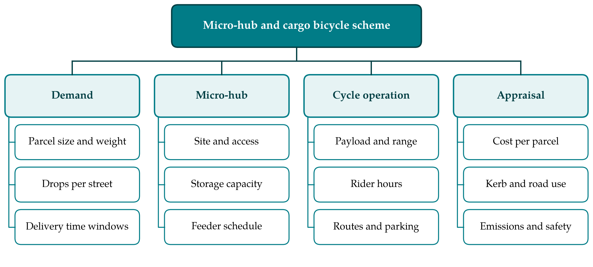
The procedure has seven steps, listed in Table 1 with the method used and the output of each. The design variables it has to settle fall into four groups, shown in Figure 1: the demand to be served, the hub, the cycle operation and the terms on which the scheme is judged. Early steps are cheap and are meant to stop unsuitable projects before detailed modelling begins.
| Step | Method | Output |
|---|---|---|
| 1. Area and baseline | Map the district; record current rounds, stops and dwell times | Boundary, baseline cost and distance per parcel |
| 2. Consignment screening | Filter parcel data by weight, volume and service type | Share of volume suitable for cycles |
| 3. Hub shortlist | Score candidate sites on access, size, tenure and cost | Two or three feasible sites |
| 4. Sizing | Continuous approximation of route length and time | Number of cycles, riders and feeder trips |
| 5. Routing refinement | Two-echelon routing model on sample days | Tested schedules and capacity margins |
| 6. Stakeholder appraisal | Multi-actor multi-criteria analysis | Agreed criteria and ranking of options |
| 7. Pilot design | Define duration, indicators and stopping rules | Pilot protocol and monitoring plan |
3.1. Step 1: Delimit the area and record the baseline
The district should be small enough for a cycle to cross in a few minutes and bounded by features that mean something operationally: a ring road, a river, the edge of a pedestrian or low-emission zone. Within it the planner records the present operation from the carrier's own scan and telematics data: rounds per day, parcels and stops per round, time spent driving, parked and walking, and failed deliveries. These figures form the baseline against which every later estimate is compared, and they should be taken over several weeks that include a peak.
3.2. Step 2: Screen the consignments
Not all freight belongs on a bicycle. The parcel file is filtered against the load box of the intended cycle by weight and by the longest dimension, and against service constraints such as timed collections, cash handling or goods needing temperature control. What remains is the addressable volume. If it is a small share of the district's parcels, the van rounds will continue alongside the cycles and the saving will be slight; the project should stop here or the district should be redrawn.
3.3. Step 3: Shortlist micro-hub sites
Candidate sites include vacant shop units, corners of car parks, railway arches, a container on public land, or a vehicle used as a mobile depot. Each is scored on a short list of practical tests: whether the feeder vehicle can reach and unload at the hours required, floor area for sorting and overnight charging, security, length of tenure and rent. Proximity to the centre of demand matters most, because every cycle tour starts and ends at the hub. A site outside the district adds an unproductive stem to each tour. The step ends with two or three sites that the property owner or the municipality has confirmed are obtainable.
3.4. Step 4: Size the operation by approximation
With the addressable volume and a hub location, the scale of the operation can be estimated without building routes. In the approximation of Daganzo (1984), the distance needed to serve N stops in a zone of area A with vehicles that each make C stops is the sum of a line-haul term, 2rN/C, where r is the average distance from depot to zone, and a local term proportional to the square root of A times N. The text by Daganzo (2005) develops the reasoning. Dividing distance by cycle speed and adding a service time per stop gives tour duration, and from that the number of tours a rider can complete in a shift, the number of cycles, and the frequency of feeder trips needed to keep the hub supplied. The same formulas applied to the van baseline give a like-for-like comparison. The estimate is rough, and its use is to show whether the scheme is within reach of break-even and which parameter the answer is most sensitive to.
3.5. Step 5: Refine with a routing model
If the approximation is encouraging, the design is tested on actual address data for a sample of days, including the busiest. A two-echelon routing formulation assigns parcels to feeder trips and cycle tours subject to load box capacity, rider hours, hub storage and any time windows. Exact solution is unnecessary; published heuristics are adequate at district scale (Cuda et al., 2015). The purpose is to expose what averages hide: the day when volume exceeds hub capacity, the tour that cannot finish within a shift, the afternoon feeder that arrives after riders have run out of work.
3.6. Step 6: Appraise from each stakeholder's position
A scheme that lowers the carrier's cost and annoys shopkeepers, or pleases the city and loses money, will not last. The multi-actor multi-criteria method of Macharis et al. (2009) asks each group, here the carrier, riders, receivers, residents and the municipality, to state its own criteria and weights, and evaluates the options separately for each. The output is a picture of who gains and who loses under each site and scale, which is the basis for negotiating kerb access, hub rent or operating hours before the pilot.
3.7. Step 7: Specify the pilot and its monitoring
The final step turns the preferred option into a time-limited pilot with rules fixed in advance. The protocol names the indicators, drawn from the baseline so that before and after are comparable: cost per parcel including hub costs, first-attempt delivery rate, van distance removed from the district, rider incidents, and complaints. It sets a duration long enough to pass the learning period and to include a peak, and it states the results at which the scheme would be extended, altered or ended.
4. Fitting the Procedure to Local Conditions
Several conditions lie outside the planner's control and should be checked at the outset. Gradient and climate limit payload and rider endurance even with electric assistance. Local rules determine whether a loaded tricycle may use cycle tracks and pedestrian streets and what motor power is permitted. Labour arrangements matter as well, since rider pay and employment status differ widely between operators and change the cost comparison. Finally, a single carrier's volume in one district may be too thin to fill a hub. Savelsbergh and Van Woensel (2016) identify collaboration between competing carriers as one of the open problems of city logistics, and a shared hub run by a neutral operator is the usual proposal, with the commercial difficulties that the consolidation centre literature records.
5. Limitations and What Remains to Be Shown
The procedure has not been applied, and its usefulness is untested. A first application would need to show that the screening and sizing steps predict pilot outcomes closely enough to be trusted for decisions, and in particular that continuous approximation, derived for van distribution, is acceptably accurate for cycle tours in an irregular street network with one-way restrictions. It would also need to show that the data the procedure assumes, parcel dimensions above all, are available in carriers' systems in usable form.
The procedure is also narrow by design. It takes demand as given and does not consider parcel lockers, off-hour delivery or receiver-led consolidation, any of which may serve the same aim at lower cost. It treats a single district, whereas a carrier will want to know how hubs in adjoining districts interact. And its appraisal step records stakeholder preferences without resolving conflicts between them.
6. Conclusion
Micro-hubs with cargo bicycles suit dense districts with small parcels and short tours, and they carry fixed costs that only sufficient volume can cover. The seven steps proposed here arrange the planning questions in order of rising effort, so that a district that fails on freight mix or site availability is set aside early and modelling is reserved for cases that merit it. Whether the procedure improves decisions is a matter for trial in practice, and the article has indicated what such a trial should measure.
Conflict of interest
To be declared by the author(s) before publication.
Funding
To be declared by the author(s) before publication.