1. Introduction
South Asia's major rivers cross borders drawn long after the irrigation systems that depend on them. The Indus system is divided between India and Pakistan under a treaty of 1960 (India and Pakistan, 1960). The dry season flow of the Ganges at Farakka is shared between India and Bangladesh under a treaty of 1996 (India and Bangladesh, 1996), and in the same year India and Nepal concluded the Mahakali Treaty on a tributary system further west. Other shared rivers, the Teesta among them, have no agreement, and on the Brahmaputra cooperation between China and India is confined to memoranda on the exchange of hydrological data.
These arrangements face a common pressure. Much of the flow originates in snow and ice, and the assessment of the Hindu Kush Himalaya coordinated by regional scientists concluded that warming will alter the cryosphere and with it the seasonal pattern of river discharge (Wester et al., 2019). Earlier modelling had already indicated that the Indus and Brahmaputra basins are especially sensitive to changes in meltwater (Immerzeel et al., 2010). A treaty that divides water by fixed quantities or fixed calendars was written on the assumption that the past is a guide to the future.
This article proposes a framework for analysing how the design of these institutions conditions negotiation when that assumption fails. It is a methodological proposal built from published theory and the texts of the agreements. It does not report the results of applying the framework, and the basins mentioned serve as illustrations of what an analyst would look at, not as findings.
2. Background
Three literatures supply the building blocks: the study of institutional design in international relations, the comparative study of water treaties, and the critical study of power in shared basins.
2.1. Institutional design
Koremenos et al. (2001) argued that states design international institutions deliberately and that the variation among them can be described on a small number of dimensions: membership, scope, centralisation of tasks, rules of control and flexibility. Their conjecture that flexibility increases with uncertainty about the state of the world bears directly on water treaties under a changing climate. From the study of common-pool resources, Ostrom (1990) identified features of long-lived institutions, among them monitoring, graduated responses to violations and accessible arenas for resolving conflict. Young (2002) added the problem of fit: an institution performs well only if its rules match the properties of the biophysical system it governs.
2.2. Water treaties and variability
The comparative water literature established that shared rivers produce far more cooperation than violence (Wolf, 1998) and that the risk of dispute rises when physical or political change outpaces the capacity of institutions to absorb it (Wolf et al., 2003). Sadoff and Grey (2002) showed that negotiations broaden when parties bargain over the benefits of water and not only its volume. On variability specifically, Fischhendler (2004) examined how treaties adapt legally to climatic uncertainty, and Drieschova et al. (2008) classified the mechanisms treaties use to deal with fluctuating flow, distinguishing fixed from proportional allocation and noting provisions for drought, consultation and amendment. De Stefano et al. (2012) combined projected variability with treaty content to identify basins whose institutions are poorly equipped for what is coming.
2.3. Power asymmetry
Design does not operate in a vacuum. Zeitoun and Warner (2006) introduced hydro-hegemony to describe how the stronger riparian shapes outcomes through its position on the river, its material power and its control of the terms of debate, so that an agreement may record an imbalance as much as resolve one. In South Asia, India is the upper riparian to Pakistan and Bangladesh and the lower riparian to Nepal and China, which makes the region unusually suited to studying how the same state designs institutions from different positions. The legal history of the agreements is set out by Salman and Uprety (2002).
3. The Proposed Framework
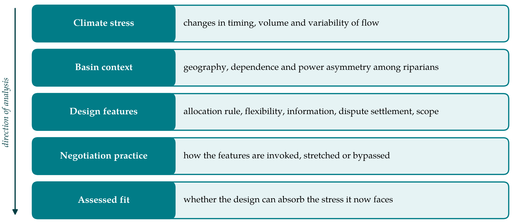
The framework arranges these ideas into a sequence of analytical layers, shown in Figure 1. Climate stress acts on a basin with a given political geography; the treaty's design features mediate between that stress and the behaviour of the parties; and the observable product is negotiation practice, from which the fit of the design is assessed. Six steps carry the analyst through the layers.
3.1. Step 1: Bound the negotiation episode
The unit of analysis is a negotiation episode: a defined period in which the parties bargain over the creation, interpretation or revision of an arrangement for a named river. Bounding matters because the same treaty can generate distinct episodes with different dynamics. Under the Indus Waters Treaty, the reference of the Baglihar project to a neutral expert and the arbitration over the Kishenganga project are separate episodes within one institution. The analyst records the parties, the river reach, the opening and closing events, and any third party involved.
3.2. Step 2: Assemble the documentary record
The primary sources are the treaty text and annexures, the published decisions of dispute settlement bodies, joint statements and the communiqués of bilateral commissions. Secondary legal and historical accounts supply context (Salman and Uprety, 2002). Because the minutes of bodies such as the Permanent Indus Commission and the Joint Rivers Commission are largely unpublished, the analyst should state which records were available and treat silence in the public record as missing information, not as evidence that nothing occurred.
3.3. Step 3: Characterise climate stress
The framework does not ask the political analyst to model hydrology. It asks for a short, sourced description of how the flow regime relevant to the treaty is expected to change, taken from published assessments (Wester et al., 2019). Three aspects are recorded: change in the timing of flow, change in total volume, and change in variability between years. The description is tied to the treaty's own terms. For an agreement that shares water in a defined dry season window, timing is the aspect that matters; for one that allocates whole rivers, it may be volume and the frequency of extremes.
3.4. Step 4: Code the design features
Six features are coded from the treaty text, each on a simple ordinal scale with the supporting clause quoted. They adapt the dimensions of Koremenos et al. (2001) to water using the mechanisms catalogued by Drieschova et al. (2008). Table 1 lists the features with the question each answers and an illustration from the region.
| Design feature | Guiding question | Illustration |
|---|---|---|
| Allocation rule | Is water divided by fixed quantity, by proportion, or by assigning whole rivers? | Indus: eastern rivers to India, western rivers to Pakistan |
| Flexibility | Does the text provide for drought, review, amendment or expiry? | Ganges: thirty-year term with provision for periodic review |
| Information | What data must be exchanged, how often and with what verification? | Indus: regular exchange of river flow data between the parties |
| Dispute settlement | Is there a graded path from joint body to third-party decision? | Indus: Commission, then neutral expert or court of arbitration |
| Scope | Does the agreement cover one use or several, one reach or the basin? | Mahakali: irrigation, hydropower and flood control on one river |
| Joint body | Is there a standing commission, and what may it decide? | Ganges: Joint Committee monitors flows at Farakka |
The standing joint body is coded as a feature in its own right because its mandate cuts across the others: it is usually the channel for data exchange and the first rung of dispute settlement. Coding should be done independently by two readers where possible, with disagreements recorded, since treaty language on matters such as consultation in times of low flow is often open to more than one reading.
3.5. Step 5: Record negotiation practice
A clause that is never invoked tells a different story from one in constant use. For each coded feature the analyst records whether, within the episode, it was invoked, by whom and with what result; whether the parties worked around it through political channels; and whether either party contested its meaning. Here the hydro-hegemony approach supplies the questions: which party controlled the timing of talks, whose data were treated as authoritative, and whether the weaker riparian complied, contested or sought outside support (Zeitoun and Warner, 2006). India's announcement in April 2025 that it was holding the Indus Waters Treaty in abeyance is an example of practice departing from text, since the treaty contains no provision for unilateral suspension.
3.6. Step 6: Compare across basins
The final step applies the method of structured, focused comparison described by George and Bennett (2005): the same questions are put to each episode, and the answers are set side by side. With a handful of cases the aim is not statistical inference. It is to see whether episodes with similar stress and different designs, or similar designs and different power relations, unfold differently, and to trace within each case how a design feature affected the course of bargaining. The assessed fit recorded at the base of Figure 1 is a reasoned judgement supported by that tracing.
4. Fitting the Framework to the Region
Several features of South Asia affect how the framework would be used. The agreements are bilateral, even where the basin has more than two riparians, so the membership dimension is nearly constant and exclusion of third states should be noted as context. No South Asian riparian is a party to the United Nations convention on international watercourses (United Nations, 1997), so its principles of equitable use and of avoiding significant harm serve as a reference point for argument and not as binding law. Hydrological data are frequently classified, which limits Step 3 to published science and makes the information feature in Step 4 especially telling. And water talks are entangled with security and domestic politics to a degree that requires the analyst to record linkage to other issues during Step 5.
5. Limitations and What Remains to Be Shown
The framework is proposed and has not been validated here. Its first weakness is the public record. If the decisive exchanges take place in closed commissions, coding of practice will be biased towards episodes that reached a tribunal or the press. Its second is attribution. Climate stress, upstream development and political hostility often arrive together, and a small set of cases cannot separate them with confidence; global studies using many treaties are better placed to estimate average effects (Dinar et al., 2015). Its third is the coding itself, where the reliability of the ordinal scales between independent readers would need to be established before results were compared.
What would show the framework to be useful is an application to several episodes by analysts from different riparian states who then compare their codings. Agreement would suggest that the scheme captures features of the institutions and not the vantage point of the observer. Disagreement would be informative too, since it would locate the clauses whose meaning is itself part of the dispute.
6. Conclusion
Treaties on South Asia's shared rivers were designed for stable hydrology and are being asked to function without it. The framework proposed in this article offers a consistent way to ask how their design shapes negotiation under that strain: bound the episode, assemble the record, describe the stress, code the design, observe the practice and compare. It draws on established theory and uses only public sources. Whether it yields reliable and useful assessments is a matter for application, which this article invites and does not attempt.
Conflict of interest
To be declared by the author(s) before publication.
Funding
To be declared by the author(s) before publication.