1. Introduction
Nepal divides into three belts running east to west: the plains of the Terai along the Indian border, the middle hills, and the high Himalaya. The hill districts hold a large rural population in villages strung along ridges and terraced slopes, separated by deep river valleys. A place a few kilometres away in a straight line may be a day's walk by trail. The same relief that isolates the villages also offers long unobstructed lines of sight from ridge to ridge, a fact that the earliest community networks in the country put to use (Thapa and Sæbø, 2011).
Mobile coverage and broadband have spread widely in the country, but the capacity delivered to a hill village is bounded by its backhaul. A base station or a community access point is only as good as the link behind it, and upgrading the radio interface without upgrading that link changes little. Brewer et al. (2005) argued that connectivity in developing regions calls for technology designed around low user density, scarce power and limited local expertise, not for a scaled down version of urban infrastructure. Backhaul in the hills is a clear instance.
Fibre offers practically unlimited capacity but is expensive to lay and to keep intact on unstable slopes. Radio is cheap to deploy across a valley but is limited in capacity and exposed to weather. Combining the two, with fibre to a point of concentration and radio beyond it, is the obvious response. This review examines what the literature says about doing so in hilly rural terrain of the kind found in Nepal.
2. Scope and Approach
This is a narrative review of published sources: research papers on fibre wireless access networks and on rural wireless networking, standard texts on radio link design, and the Recommendations of the International Telecommunication Union that link planners use. No systematic search was conducted, and the article reports no deployment and no measurements of its own. Reference to Nepal draws on general geographic facts and on published accounts of rural networks there and in neighbouring regions. Where the literature offers no evidence specific to Himalayan conditions, the review says so.
3. The Fibre Wireless Architecture
Research on combined optical and wireless access took shape in the late 2000s. Sarkar et al. (2007) described a hybrid network in which a passive optical network reaches a set of gateways and a wireless mesh extends from them, and set out the associated problems of gateway placement and routing. Ghazisaidi et al. (2009) surveyed the field under the name fibre wireless, or FiWi, access. The guiding principle in both is that fibre should go as far as cost allows, and radio should cover the part where trenching or stringing cable cannot be justified. Where the boundary between the two falls depends on terrain and demand.
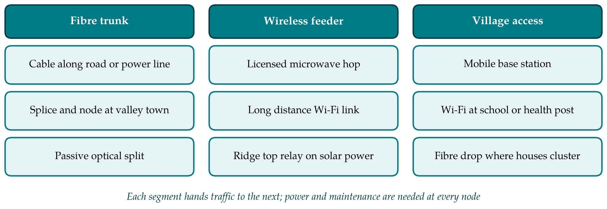
The optical side of this architecture relies on passive optical networks, in which one fibre from a central office is divided by unpowered splitters among many terminals (Kramer and Pesavento, 2002; Effenberger et al., 2007). The gigabit capable variant standardised by the ITU supports a physical reach of 20 km (ITU-T, 2008), and Kazovsky et al. (2007) reviewed the generations expected to follow. For a rural planner the important property is that nothing between the central office and the terminal needs electrical power. Figure 1 sketches how a fibre trunk, a wireless feeder and village access fit together in a hill district.
4. The Fibre Segment
Standard single mode fibre has very low attenuation, of the order of 0.2 dB per kilometre near 1550 nm, and its characteristics are fixed by Recommendation G.652 (ITU-T, 2016). Reach is therefore seldom the difficulty. The difficulty is the route. In hill districts the practical routes are the road corridor and the electricity network. Buried or ducted cable along a hill road is exposed to slope failure, road widening and repair works, and a single landslide can sever it.
Aerial cable avoids the ground. All dielectric self supporting cable is designed to be strung on power line structures without a metallic messenger, and its testing and performance are covered by a dedicated standard (IEEE, 2019). Sharing poles or towers with the electricity utility gives a right of way that already exists and is already patrolled. Its drawbacks are that the fibre route then follows the power route, which may not pass near the villages that lack service, and that access for splicing depends on the utility. In either form of construction, a ring or a second route is the standard protection against cuts, and in hill terrain a second route is often unavailable, which is one argument for a radio link as backup even where fibre exists.
5. The Wireless Segment
Radio links for backhaul fall into two groups that differ in regulation, cost and engineering practice: licensed point to point links, and links in unlicensed bands built from wireless local area network equipment. Table 1 compares these with the fibre options discussed above.
| Option | Suited to | Main limit in hill terrain | Sources |
|---|---|---|---|
| Buried or ducted fibre | Trunk along road corridors | Landslides and road works cut the cable | ITU-T, 2016 |
| Aerial fibre on power lines | Trunk where a grid route exists | Route tied to the power network | IEEE, 2019 |
| Passive optical network | Clustered settlements near a node | Scattered houses raise cost per connection | ITU-T, 2008; Effenberger et al., 2007 |
| Licensed microwave | Ridge to ridge feeder of high availability | Tower, power and licence costs | Freeman, 2007; ITU-R, 2021 |
| Millimetre wave (E-band) | Short high capacity hops | Rain attenuation in the monsoon | Wells, 2009; ITU-R, 2005 |
| Long distance Wi-Fi | Low cost links to small villages | Interference, protocol limits, upkeep | Patra et al., 2007; Raman and Chebrolu, 2007 |
5.1. Licensed microwave and millimetre wave links
The design of a line of sight microwave hop is mature engineering, set out in standard texts (Freeman, 2007) and in Recommendation P.530 (ITU-R, 2021). The planner establishes the path profile, checks clearance of the first Fresnel zone for the range of atmospheric refraction expected, computes the free space loss and the fade margin, and predicts availability from multipath and rain statistics. Hill terrain helps and hinders. Paths between ridges clear the ground by hundreds of metres, so obstruction is rarely a concern once sites are chosen, and where a ridge does intrude the diffraction loss can be estimated by the methods of Recommendation P.526 (ITU-R, 2019). On the other hand, good radio sites are high, remote and without road or power.
Rain sets the upper limit on frequency. Specific attenuation rises steeply with frequency and rain rate, as modelled in Recommendation P.838 (ITU-R, 2005), and the rain rate exceeded for a small fraction of the year is taken from the maps of Recommendation P.837 (ITU-R, 2017). Nepal receives most of its rain in the summer monsoon, and intense rainfall on the windward slopes is to be expected. Links below about 10 GHz are little affected and can span tens of kilometres. E-band equipment in the 71 to 76 and 81 to 86 GHz allocations offers capacity comparable with fibre over short hops (Wells, 2009), but in a monsoon climate its range at high availability is short, which confines it to the last few kilometres from a fibre node or to use with a lower frequency fallback.
5.2. Long distance links in unlicensed bands
A second tradition builds rural links from mass produced Wi-Fi radios with high gain directional antennas. Chebrolu et al. (2006) measured the behaviour of such links over tens of kilometres in rural India, and Raman and Chebrolu (2007) distilled the lessons: the standard medium access protocol performs poorly over long distances, external interference matters even in the countryside, and tower height dominates cost. Patra et al. (2007) replaced the contention protocol with time division and added loss recovery, raising throughput on long and lossy links considerably.
Nepal has its own history here. A community network begun in the Myagdi district in the early 2000s linked mountain villages to each other and to a town with long distance Wi-Fi relayed through stations on high ridges, and came to support schooling, telemedicine and local commerce (Thapa and Sæbø, 2011). The published accounts establish that such links are technically feasible in Himalayan terrain with modest equipment. They also record that relay stations far from any road depend on solar power and on people willing to climb to them when something fails.
6. Power, Maintenance and Institutions
The most sobering paper in this literature is that of Surana et al. (2008), who examined why rural wireless networks that worked as pilots later decayed. The causes they document are seldom radio problems. Poor quality grid power destroyed equipment, faults were hard to diagnose from a distance, spare parts were far away, and trained local staff were scarce and tended to move on. Their remedies are correspondingly plain: power conditioning and low voltage disconnects, remote monitoring with an independent management channel, and designs that local operators can repair.
These findings transfer directly to the hills of Nepal, where a relay site may be hours on foot from the nearest road and inaccessible for days during the rains. They argue for fewer and better protected active sites, for passive optical plant wherever fibre is used, for solar supplies sized for the cloud cover of the monsoon months, and for budgeting maintenance as a recurring cost from the start. The earthquake of April 2015 added a reminder that masts, cable routes and power supplies in the hills share the same hazards, so route diversity should mean diversity of hazard and not only of path.
Institutional arrangements decide who bears these costs. Universal service funds financed by levies on operators are the usual instrument for rural backhaul, and Nepal has such a fund under its telecommunications regulator. The literature on community networks suggests that local ownership improves upkeep (Thapa and Sæbø, 2011), while licensed spectrum and fibre rights of way are normally held by national operators and utilities. A fibre wireless chain therefore tends to cross organisational boundaries exactly where it crosses from fibre to radio.
7. Gaps and Future Work
Several questions are poorly covered. The ITU rain and multipath prediction methods are global models, and published long term link measurements from the Himalayan foothills against which to test them are scarce. Orographic rainfall varies strongly over short distances, so a rain rate taken from a global map may misstate the conditions on a particular slope. Measurement campaigns on a few representative paths would be valuable to planners throughout the region.
Cost studies comparing aerial fibre on power lines with multi hop microwave over realistic hill routes, including maintenance over many years, are also lacking in the open literature. The optimal placement of the fibre to radio boundary, treated in the FiWi literature for flat urban layouts (Sarkar et al., 2007), has not been worked out for terrain where line of sight, road access and landslide risk all vary from site to site. Finally, there is little published evidence on the long term survival of rural networks in Nepal after external funding ends.
8. Conclusion
The components needed for fibre wireless backhaul in hilly rural districts are all established: low loss fibre and passive optical networks, microwave links planned with internationally agreed methods, and inexpensive long distance radio in unlicensed bands. The literature indicates that fibre belongs on the road and power corridors, licensed microwave on the ridge to ridge feeders, and low cost radio on the final links to small settlements, with millimetre wave links restricted by monsoon rain to short hops. It indicates just as clearly that power, access for maintenance and stable local institutions determine whether a network lasts. Evidence specific to Himalayan propagation and to long term costs in such terrain is the main gap.
Conflict of interest
To be declared by the author(s) before publication.
Funding
To be declared by the author(s) before publication.