1. Introduction
Southern India holds the largest remaining population of the Asian elephant (Elephas maximus), spread through the forests of the Western and Eastern Ghats in a landscape that is also densely farmed. The elephant receives the highest level of legal protection in the country, being listed in Schedule I of the Wild Life (Protection) Act (Government of India, 1972), and has been the subject of a national conservation programme, Project Elephant, since 1992. Protection of the animal has not removed the friction between elephants and people. A national task force described conflict as the most pressing problem in elephant conservation and called for it to be managed at the scale of landscapes (Rangarajan et al., 2010).
Corridors concentrate the problem. Where a strip of forest a kilometre or less in width joins two larger blocks, elephants moving between them pass close to fields and houses on either side. A national survey identified and described such corridors and recommended that they be secured through legal protection, purchase or voluntary agreements (Menon et al., 2005). Securing the land is a beginning. People at the edge of a newly protected corridor still need their crops and their safety, and the measures taken on their behalf affect whether elephants can continue to use the passage.
This article proposes a framework for planning mitigation around such a corridor. It is written for forest department staff, local government and conservation organisations working together at a single site. No case is reported and no data are presented; the framework is a proposal assembled from published work, and it has not been validated here.
2. Background
The design rests on what is known about why elephants raid crops, on the record of the measures used against them, and on the social side of conflict.
2.1. Crop raiding by Asian elephants
Elephants do not raid at random. In his studies in southern India, Sukumar (1990) found that adult males entered cultivation far more often than members of female-led family groups, that raiding followed the calendar of crops such as finger millet and paddy as they matured, and that cultivated plants offered more nutrition than wild forage at the same season. The pattern has been interpreted as a high-risk, high-gain feeding strategy of males (Sukumar, 2003). Work on African elephants reached a compatible conclusion: the level of conflict in an area was poorly predicted by elephant numbers and seemed to depend on the behaviour of particular males (Hoare, 1999). Because raiding is tied to particular animals, crops and months, mitigation can be targeted in place and season.
In fragmented landscapes elephants also depend on small features. In the plantation-dominated Anamalai hills they were found to move along rainforest fragments and riverine vegetation, using them as refuges by day within a matrix of tea and coffee (Kumar et al., 2010). Loss of such cover pushes animals into the open and closer to people.
2.2. Measures and their record
A wide range of measures has been tried, and reviews agree that none works everywhere or for long without upkeep (Fernando et al., 2008; Shaffer et al., 2019). Table 1 summarises the main types. Electric fences and trenches are effective while maintained and fail when maintenance lapses. Evidence for deterrents is mixed: beehive fences reduced crossings by African elephants in Kenyan trials (King et al., 2009), whereas a controlled comparison in Sumatra found that chilli-based deterrents added nothing to conventional guarding (Hedges and Gunaryadi, 2010). A study in Assam compared the interventions that villagers used against crop-raiding elephants and found that effectiveness differed among them and depended on the combination applied (Davies et al., 2011).
| Measure | How it is meant to work | Documented limits |
|---|---|---|
| Guarding and early warning | Farmers detect elephants and drive them off or avoid them | Labour, lost sleep and risk to guards (Barua et al., 2013) |
| Electric fence | Non-lethal shock deters crossing | Fails without maintenance; some males learn to break fences |
| Elephant-proof trench | Physical barrier along the forest edge | Erodes in heavy rain; gaps at streams and roads |
| Chilli and other deterrents | Irritant or alarm discourages entry | Little gain over guarding in trials (Hedges and Gunaryadi, 2010) |
| Beehive fence | Elephants avoid disturbed bees | Evidence mainly from African elephants (King et al., 2009) |
| Change of crop or land use | Removes the attraction near the edge | Depends on markets and on farmers' consent |
| Compensation or ex gratia relief | Offsets loss and reduces retaliation | Delays and uneven reach (Karanth et al., 2013) |
2.3. The social dimension
How people respond to elephants is not a simple function of what they lose. Dickman (2010) showed across many conflicts that attitudes are shaped by trust in authorities, by beliefs and by the sense of having a say, as much as by the size of the damage. Costs that never appear in a damage register, among them nights spent guarding, children kept from school, fear and the effort of pursuing a claim, can outweigh the crop loss itself (Barua et al., 2013). Studies around southern Indian reserves have documented both the extent of losses and the shortcomings of compensation as experienced by households (Karanth et al., 2013; Gubbi, 2012).
3. The Proposed Framework
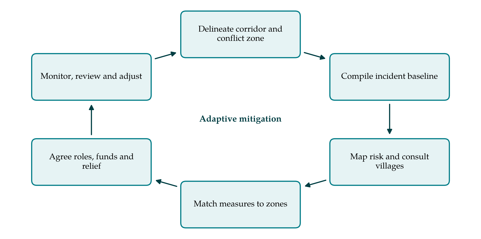
The framework has six stages arranged as a cycle (Figure 1). The cycle is deliberate: the measures are treated as trials whose results inform the next round, in the manner of adaptive management (Walters and Holling, 1990).
3.1. Stage 1: Delineate the corridor and the conflict zone
The corridor is mapped from evidence of use, such as dung, tracks, camera-trap records and the knowledge of forest watchers, and not from the notified boundary alone. Around it a conflict zone is drawn to take in every village and estate whose land elephants reach from the corridor. Within the corridor the plan identifies the points where passage is narrowest and the features, such as stream beds and patches of cover, on which movement depends.
3.2. Stage 2: Compile a baseline of incidents
Before any new measure is installed, incidents are compiled for several past years from compensation claims, forest range records and village registers, each with its date, place, crop or property and, where known, whether a lone male or a herd was involved. Official records undercount, because many losses are never claimed, so the baseline is supplemented by a simple incident log kept in each village from the start of planning. The same definitions and forms are used throughout the life of the plan, since a change in recording is easily mistaken for a change in conflict.
3.3. Stage 3: Map risk and consult affected villages
Incidents are plotted against fields, crops, water, cover and elephant paths to show where and when risk is highest. The map is then taken to the villages. Meetings are held separately with groups whose exposure differs, for example landless labourers who walk at dawn, women who collect firewood, and farmers at the forest edge, and each is asked what it fears, what it already does and what it would be willing to maintain. This stage settles which problems the plan must address first, and safety of people takes precedence over crop loss.
3.4. Stage 4: Match measures to zones
Measures are assigned by zone. The governing rule is that barriers run parallel to the direction of elephant movement and never across it. Fences and trenches are placed to protect the outer edge of settlements and fields and to guide animals along the corridor, with the passage itself left open. A barrier that closes a corridor displaces conflict to the next village and defeats the purpose of protection, a trade-off between mitigation and connectivity that has been set out formally for heterogeneous landscapes (Goswami and Vasudev, 2017). Close to the passage, the plan favours early warning, lighting of paths, safe timing of travel and, where farmers agree, crops that elephants do not eat. Each measure is recorded with the party responsible for its upkeep.
3.5. Stage 5: Agree roles, funds and relief
A measure with no owner decays. The plan names who maintains each fence section, who operates the warning system, who responds at night and how they are paid or supplied. It sets a procedure for relief payments with a stated time limit and a local point of contact, so that claimants are not required to travel repeatedly to a distant office. Funds for maintenance are budgeted for the whole planning period and not only for construction.
3.6. Stage 6: Monitor, review and adjust
Monitoring follows three things: incidents, using the baseline definitions; the working condition of each measure, checked on a fixed schedule; and continued use of the corridor by elephants, including females with calves. A review each year compares zones and seasons with the baseline and decides what to keep, repair, move or abandon. Because conflict varies from year to year with rainfall and cropping, conclusions are drawn from several seasons and not from one.
4. Fitting the Framework to a South Indian Corridor
Several features of the region bear on application. Land beside corridors is commonly a mix of small holdings, revenue land and private estates, and each owner has different means and incentives; estate managements can maintain a fence that a group of smallholders cannot. Forest department staff, elected village councils and existing village forest or eco-development committees provide the institutional base, and the plan works through them instead of creating a parallel body. Cropping calendars, and with them the season of peak raiding, differ between the wetter western slopes and the drier plateau to the east, so the timing of guarding and of monitoring is set locally.
Relief for crop and property damage and for injury or death is paid by state forest departments under their own rules, and rates and procedures differ between neighbouring states. A corridor that lies on or near a state boundary therefore needs the plan to record which rules apply to which village, and to arrange that warnings about elephant movement pass between the field staff on either side. Linear infrastructure deserves the same attention: where a road, railway or canal crosses the corridor, the plan notes the crossing points elephants use and the hours at which they use them.
5. Limitations and What Remains to Be Shown
The framework is a proposal and has not been tested. Its central assumptions are that barriers aligned with movement reduce incidents without reducing passage, and that measures owned locally last longer than those installed from outside. Both are plausible from the literature and neither is established for corridors in particular. An application would need to show, against a multi-year baseline and preferably against comparable villages outside the plan, that incidents and human casualties fell, that elephants went on using the corridor, and that conflict was not simply displaced to neighbouring areas.
Some causes of conflict lie beyond the reach of a site plan. Habitat loss elsewhere in the range, new roads and canals, and changes in cropping driven by markets all alter elephant movement at scales larger than a corridor. A local plan can reduce harm at one place; it cannot substitute for the landscape-level management that the national task force recommended (Rangarajan et al., 2010).
6. Conclusion
Mitigation around an elephant corridor has two aims that pull against each other, protecting people beside the passage and keeping the passage open. The framework proposed here addresses both by planning from a delineated corridor and a recorded baseline, by involving the affected villages in mapping risk, by aligning barriers with elephant movement, by fixing responsibility for upkeep and relief, and by revising the plan in the light of monitoring. Whether it delivers fewer incidents with undiminished use of the corridor can be settled only by applying it and measuring the result.
Conflict of interest
To be declared by the author(s) before publication.
Funding
To be declared by the author(s) before publication.